Students in Romania
The following is a copy of a report first published in the Journal of the London University Caving Clubs in 1968 and now quite rare. It is reproduced here to give context to Tony Philpott’s seldom seen film of the expedition and to some of his many photos of the trip. As far as we are aware, the frequently mentioned ‘Final Report’ was never published. The archaic spelling of ‘Rumania’ in the report has been retained. It is also worth noting the eclectic mix of imperial and metric measures, marking a transition period in technical usage at this time.
The Joint British Universities Speleological Expedition to Rumania, 1968
C.J. Gilmore, Leader J.W. Dolman, Organizer
Introduction
In 1967, John Dolman visited Rumania and was impressed by some caves there. Early in 1968 he and a group of colleagues at Q.M.C. set the wheels of organisation in motion. The final result was for twenty people from seven British universities, one College of Technology, two research institutes and two schools to arrive in Rumania in August 1968. The party had all the equipment necessary for a full-scale scientific attack on large cave systems, and after a few days’ getting to know the area and organizing the campsite, work began. All work was carried out in conjunction with the Rumanian Institute of Speleology, the Rumanian Academy and the Postojna Institute of Speleology (Yugoslavia).
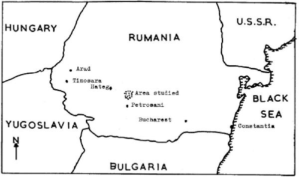
Figure 1. Sketch map showing region of Romania visited.
The limestone area visited lay between the towns of Hateg and Petrosani NE of the Retezat mountains in the Transylvanian Alps (fig.1 ) . The exposed limestone area was small, covering some 200 sq.km, with very little surface drainage. The scenery was typical of that of Karst areas in other parts of eastern Europe.
There are three main cave systems in the area. The largest of these, Sura Mare, is known from its huge resurgence. This is the main drainage channel for the whole region. The resurgence lay about one kilometre from the campsite, up an impressive limestone gorge and was about 40 m high and 15 m wide. The normal flow rate of the stream leaving the cave was about 2,000 galls/min. The furthest point in the cave reached previously by anyone was about 4 km in. This had been reached in 1967 by John Dolman, and had been named Mendip Chamber. The cave was fed by sinks some 4 to 5 km distant and 300 m higher. The most important of these were Lunca Ponorlui and Fundatura Ponorlui.
The second system was much less extensive. It consisted of a smaller resurgence cave, Pestera Sura Mica (= Pestera lui Cocolbea). This was 200 m long as far as the previously unexplored sump.
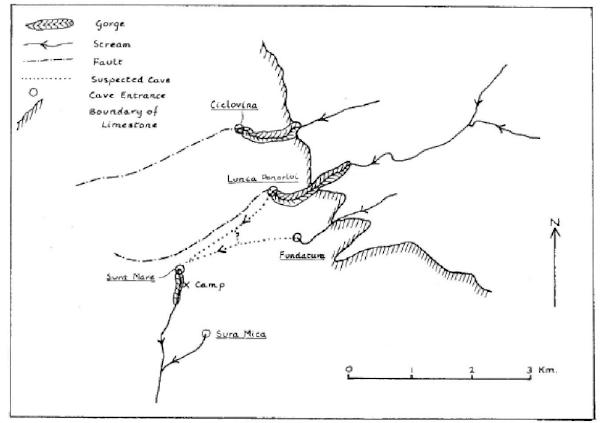
Figure 2. The main caves of the area.
The third system was about 5 km from Sura Mare, the Ciclovina system. Though the Rumanians had done a through trip of this from the top to the resurgence, it had not been surveyed.
Most of the work done took place in Sura Mare , the first of the three.
CAVE EXPLORATION
Sura Mare :
It had been hoped to prove a connection between the: resurgence of Sura Mare and the sinks of Fundatura and Lunca Ponorlui , and the problem was attacked from both ends.
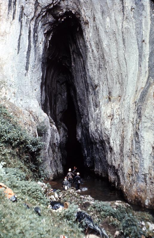
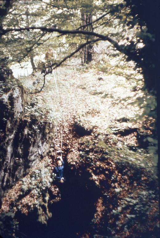
The entrance to Pesta Sura Mare. © R.A. Philpott
A base camp was established in Mendip Chamber in Sura Mare consisting of a large amount of concentrated food and heating equipment, and also spare caving equipment. Using this base, several pushes were made, eventually finding a sump with a turmoil of water coming out of it 1,000 m. further on. Attempts to by-pass this obstacle by finding high-level passages in the roof of the cave found a well decorated passage about 500 m long. This ended in a unscalable shaft down which water cascaded.. This was called ‘Green Inlet ’ owing to the colour of the water at this place. However, no by-pass to the sump was found, and a high-grade survey of the cave was begun.
Descending Fundatura pothole. © R.A. Philpott
Attention was now transferred to the sinks. First the Fundatura pothole was explored, pack-horses being used to carry the equipment up the mountain. The results were rather disappointing. Two trips revealed a pothole with 4 pitches totaling 70 m in depth, which led into a mud-blocked chamber.
The sink at Lunca Ponorlui was attacked by seven cavers for a week, under the direction of Derek Abraham. This sink drained an area of 10-15 sq km, but was so blocked up with mud and debris that all efforts to clear it were·· unsuccessful.
Finally various dolines and shakeholes in the line of Sura Mare were attacked and eliminated one by one , though at the bottom of one shakehole the sound of running water could be heard.
No dye-testing could be done in these sinks since immediately a dye-testing programme was worked out, caving activity was stopped by a week of heavy flooding.
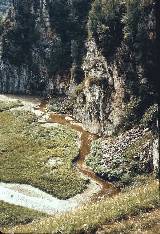
The large sink, Lunca Ponorlui. © R.A. Philpott
Sura Mica :
Chris Gilmore dived the terminal sump in this cave. The sump sloped deeply at 45° in a passage 2 m square. This dive helped to confirm the results of the chemical analysis of the water, that the sump is very long and could probably not be tackled by a solo diver using a single bottle.
Ciclovina Ponorlui:
This sporting and well decorated sink was fully explored photographed and surveyed (CRG grade 4), and further details will be published in the main report.
BIOLOGICAL WORK
Biological Officer - Paul Cornelius
The fauna of the entrance regions of the cave had already been collected by the Rumanians, and no attempt was made to repeat this work. The Rumanian workers, led by Professor Orghidan of the Bucharest Speleological Institute, had found about 200 invertebrates in the bat guano deposits in the entrance to the cave. They had found also that of these only four species could not be found outside in the surrounding countryside.
To complement the work of the Rumanians, all pools in the side of the main streamway up to a height of about six feet from the water level were searched for fauna. None was found despite intensive searching to within 200 m of Mendip Chamber.
The reason for this absence of fauna was probably the fast-flowing nature of the streamway. Any fauna would soon be washed out of the cave, and a true cave fauna could not develop.
Possible collecting grounds that were not visited included the large rimstone pools in Mendip Chamber, Green Inlet Passage and the sandy bottom of the main streamway. It was possible, though in the author’s view unlikely, that there was an interstitial fauna in this habitat. Before these places could be collected from, severe flooding of the whole system prevented access.
Conclusion
The dark zone of Sura Mare had such a large volume of water flowing through it that any fauna attempting to become established there would soon be washed out. Any fauna found in this region would probably be of terrestrial origin and only of passing interest to the bio-speleologist. The fauna of the entrance zone had been studied by the Rumanians.
CHEMISTRY
Chemical Officer - Graham Eaton
Introduction :
It was hoped from the chemical analysis of cave water in the area to make predictions about which sinks fed “which resurgences and to answer related questions. A programme involving determinations of pH, total hardness, alkaline hardness, non-alkaline hardness, calcium content and magnesium content was embarked upon, using a pH meter and standard volumetric analytical apparatus. Considering the difficulties of working under field conditions and the remoteness of the site from normal laboratory facilities, Graham deserved praise for the consistently high standard of results obtained.
Results:
The only cave investigated completely was Pestera Sura Mare. A total of four samples was taken at approximately 40 m intervals. These were the entrance, the small inlet, a long pool above the waterfall and the final sump. The sinks for this cave were not investigated.
Samples were also taken from sinks known to connect with Sura Mare, and from the resurgence itself. Though flooding halted the collecting programme, it has been possible to draw some interesting conclusions from the results. However, since these have not yet been fully analysed the conclusions will be held over until the final report comes out.
GEOLOGY
Geological Officer - John Warbrook
Introduction:
The geology of the region was studied with a view to supplementing the CD.the geomorphological work (see below). The two valleys associated with the two caves Pestera Sura Mare and Pestera Sura Mica were mapped and studied in detail geologically. The specimens collected are still being analysed and a detailed account must wait until the full report is published.
Preliminary discussion :
The valley through which the stream flowing out of Sura Mare flows is a Jurassic/Cretaceous sedimentary basin. The majority of the Mesozoic sediments were deltaic or on-shore in type with conglomerates being predominant in Lias and Dogger times. These were succeeded by thick limestone, which proved difficult to map due to the absence of persistent marker horizons. The overlying Cretaceous rocks were sandstones and shales with local grit/ conglomerate horizons.
The western edge of the Jurassic/Cretaceous basin was a fault bounded with Senonian faulted against mica schists of uncertain age. To the north-east of the basin, beds of lower Jurassic age rested unconformably on the mica schists.
CAVE GEOMORPHOLOGY
Carried out by John Dolman and Derek Abraham
Introduction:
Severe flooding of the cave Sura Mare prevented study of more than the gorge at the entrance to the cave and the first 1,000 m inside it. The latter was done under conditions of flood and international political unrest, and was therefore made more difficult than the task would otherwise have been. Two main erosion levels were found throughout the length of the cave from Mendip Chamber to the entrance. There were smaller channels above the present entrance of Sura Mare, and it is likely that several small channels in one horizontal plane joined together and cut down into the present cave. It is likely that the downward cutting has been arrested due to the stream’s having attained its natural graded profile.
The gradient of the main streamway in Sura Mare is only a few degrees along the known part of the cave. There must, therefore, be steeper sections undiscovered as there is 300 m vertically between sink and resurgence . Fundatura, for example, consists of a hectic series of vertical pots one after the other. It may be that when the whole system has been studied in detail it will be found to be a near text-book example of karstic development. Mendip Chamber, however, 200 ft high by 300 ft long and 100 ft. wide (grade 1! ) is mysterious. Just what causes a chamber of this size to develop in an ordinary stream passage? The Yugoslavs have some theories about this, but we are awaiting their conclusions.
PHOTOGRAPHY
Photographic Officer - Tony Philpott
Tony had three main objectives:- 1) To record the day to day running of the expedition; 2) To record new cave discoveries; and 3) to film the region itself. In particular a 16 mm film was shot using film provided by the ECC and which remained their property. Rumanian television sent a couple of their cameramen to cover us, and in all fairness it must be said that they handled their difficult film-stars in their difficult surroundings with dogged perseverance, great technical skill and an enviable source of patience and good humour. They were kind enough to allow us to use their own lighting equipment underground.
Meanwhile , our own Photographic Officer was filming and snapping shots of camp life, cave features , new cave systems, the local peasants, people eating sponsors’ products and a hundred and one other subjects. It is sad that the cost of photographic reproduction makes it impossible to publish more of these results .
SURVEYING:
Survey Team Leader - H.K.V. White Team - J. Forder, G.Griffiths, C.T. Little, D.Pearce, J.Sheppard. Assistants - H.J . Ball, P.F.S. Cornelius, M.J. Gallagher.
This team was well led, and it worked hard , achieving more than any other facet of the expedition. The amount of work done makes it impossible to do more here than simply list the surveys produced, CRG grade 4 to 5sC.
- Pestera Sura Mica (Pestera lui Cocolbea).
- The Valley of Pestera Sura Mica.
- Pestera Sura Mare (part only).
- The valley and gorge of Pestera Sura Mare .
- Pestera Ciclovina.
- Fundatura Ponorlui .
- Small, unamed cave near Pestera Sura Mare.
- An area map was compiled from existing maps.
These surveys will be published in the final report.
Instruments:
Simple instruments were used and techniques involving complex calculations were avoided. Some of the survey trips into Sura Mare were arduous due to protracted standing in 1-4 feet of swiftly flowing water . The instruments used underground were compass, tape, Abney level and candles for targets. Surface surveys used the same equipment except that ranging rods were used as targets. Fore- and back- sights were taken above and below ground, and all slopes of 3° or more were corrected to the horizontal reading . Plane tabling was used to fill in details on the maps where appropriate, especially to fill in geological features.
RELATIONS WITH LOCAL POPULATION
The: local people were a peasant community for whom the communal way of life was not entirely appropriate due to the ruggedness of the terrain. Consequently, they did not have all the public facilities enjoyed by people in more accessible parts of the country, such as roads and electricity.. They were a proud, healthy, happy people and we welcomed their generous hospitality and uninhibited interest in our activities.
CONCLUSIONS
The expedition worked for one month under difficult conditions and over rough terrain. A great deal was achieved. A week of heavy rain in mid-August greatly impaired our work and turned our camp into a quagmire. However, spirits revived and the work went on.
The Rumanian Institute of Speleology was pleased with our research and even paid a contribution to the expedition funds. They have invited us to return in August 1969 to work in the limestone massif in the Retezat mountains on the other side of the valley. This region has great potential, but is somewhat inaccessible. An expedition is being planned for the summer of 1969, and anyone who might be interested should contact John Dolman, 155, Victoria Park Road, E.9. A little further work on the Sura Mare system is also planned.
Finally, thanks and praise are due to Chris Gilmore for his excellent leadership of the largest student speleological expedition to leave this country to date He had to cope with a team of twenty, most of whom did not know each other; with severe floods; two cave rescue alerts (fortunately false alarms); diplomatic relations with the local peasants and with the Secretary of State of Rumania; with the prospect of a military invasion in the absence of reliable first-hand radio reports; and an epidemic affecting the lower part of the gut! Whatever this expedition might have achieved it owes in large part to Chris’s untiring sound judgement and good nature, both above and below ground.
Expedition Members :
| Name | Institution | Role |
|---|---|---|
| C.J . Gilmore | - Bristol | Leader |
| J.W. Dolman | - Q.M.C. | Secretary |
| P.F.S. Cornelius | - Q.M.C.* | Assistant Secretary |
| D. A. Abraham | - Q.M.C. | Treasurer |
| M. C. Nott | - Q.M.C. | Finance Officer |
| J .P. Warbrook | - Q.M.C. | Geological Officer |
| G. Eaton | - Birkbeck* | Food Officer |
| R.A. Phllpott | - Bristol | Photographic Officer |
| H.K.V. White | - S.W.E.T.C. | Survey Officer |
| H.J. Ball | - M.A.F.F. | |
| N.R. Clatworthy | - Sussex | |
| J. Forder | - Oxford | |
| M.J. Gallagher | - Essex | |
| G. Griffiths | - O.S. | |
| C.T. Little | - Oxford | |
| D.A. Peace | - Oxford | |
| J.G. Sheppard | - Oxford | |
| D.T. Underhill | - Birmingham | |
| A. Wadham | - Q.M.C.* | |
| Eve Wheeler | - Bristol |
- Indicates now left institution in question.
Paul Cornelius
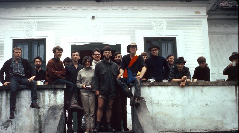
The Expedition Team. Photo © R.A. Philpott